|
|
|
Armenia in the Aftermath of Mudros: Conflicting claims and Strife with the Neighbors By Andrew Andersen and Georg Egge
|
|
|
|
The surrender of Ottoman Turkey on October
30, 1918, and the subsequent end of World War I in November, 1918, resulted
in evacuation of regular troops of the defeated Central Powers from most of
the Caucasus. However, in accordance with Clause 11 of the Mudros Armistice,
the Turkish troops were allowed to occupy the territories of Batum and Kars
left to the ottoman Empire by the Treaty of Brest-Litovsk for an indefinite
period of time until and if ”demanded by the Allies after investigation”[1].
At the same time, the Ottoman Ministry of War issued a special directive
according to which thousands of Turkish officers and soldiers were
unofficially left at the service of the republics of Azerbaijan and North
Caucasus in order to keep them within the sphere of Turkish influence[2]. The future of the self-proclaimed republics
of the South Caucasus however, still remained unclear. The treaties of
Brest-Litovsk and Batum were now both null and void thus allowing Armenia and
Georgia to claim the territories previously lost to the Turks but at the same
time, the recognition of Georgia, Armenia and Azerbaijan was withdrawn as
well[3].
The victorious allies initially tended to consider them as temporarily
breakaway Russian territories but the development of the crisis situation in
and around revolutionary Russia in combination with current inability of the
two fallen empires to satisfy their ambitions in the region, gave the new
nations of the South Caucasus a historical chance to establish/recover[4]
their statehood, and as early as in November 17 the allied command in the
Middle East declared that the representatives of Britain, France and the USA
were ready to establish relations with the de-facto governments of Armenia,
Azerbaijan and Georgia[5].
Besides the problem of diplomatic recognition accompanied by a variety of
other political as well as economic problems, the period of nation-building
in the South Caucasus was marked by territorial disputes and conflicting
claims, that caused serious troubles for all the nations of the region not
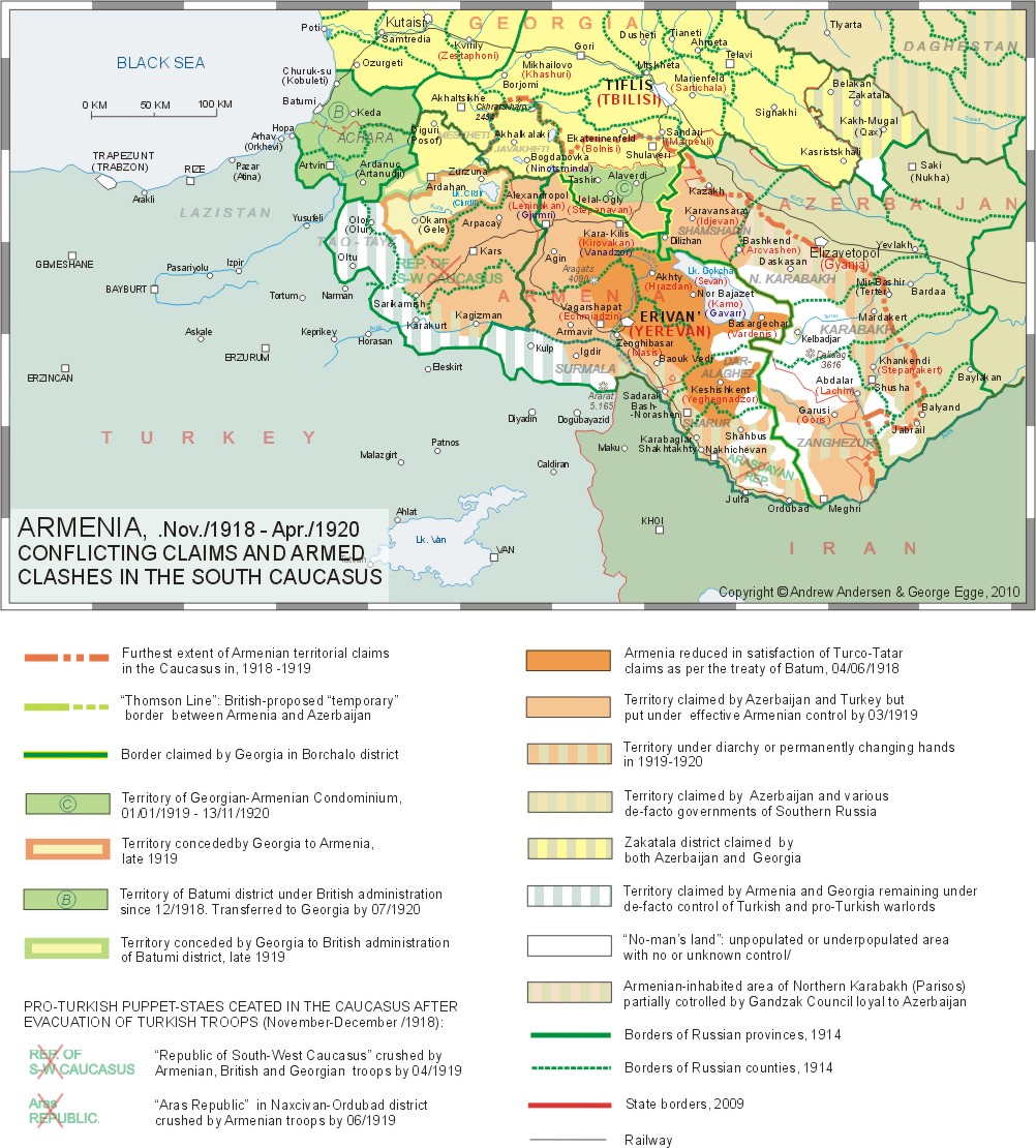
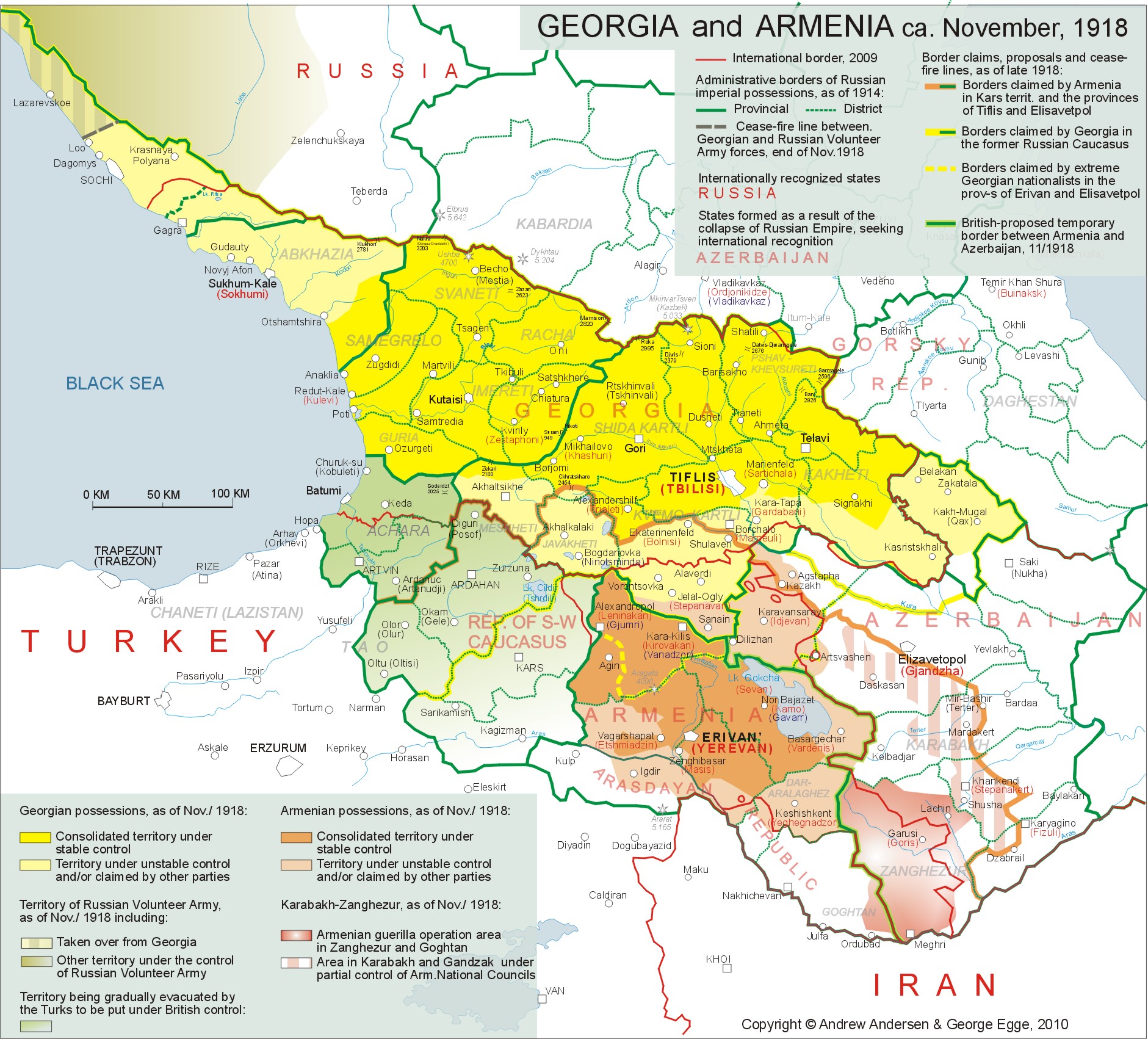
excluding Armenia. As of late October, 1918, the Democratic
Republic of Armenia claimed a considerable part of the former Russian South
Caucasus that included the whole of the province of Erevan, all the four
districts of Kars territory, the counties of Akhalkalaki and Borchalo in the
province of Tiflis and in the province of Elizavetpol – the whole Zanghezur
county as well as mountainous parts of the counties of Elizavetpol,
Javanshir, Karyaghino, Shusha[6]
and Kazakh (see Maps 2
and 3). The above claims
were based on the principle of historical belonging of the above territories
to ancient and early mediaeval Armenian states and on ethnic principle, since
most of the territories in question had either Armenian majority or at least
heavy presence of Armenians. Some of the Armenian elites also considered
laying claims to the territory of Batum, so that landlocked Armenia could
gain access to the sea. The Armenian territorial claims were in
sharp conflict with the aspirations of Azerbaijan and Georgia, not to mention
Turkey. The political elites of Azerbaijan were also basing their claims on
both historical and ethnic principles. In terms of history they tended to
disregard the earlier periods when the South Caucasus was dominated by
Armenian and Georgian states but put an emphasis on the period that started
from the late 14th century when the area was turned into the realm
of Kara-Koyunlu and later of the Safavids both of whom they considered to be
the fore-founders of modern Azerbaijan. Following the above principle, there
was no place left for Armenia on the map at all. Even the tiny enclave left
for the Armenians as per the Treaty of Batum, was according to the leadership
of Azerbaijan inalienable part of their new-born country. As for the ethnic
composition of the territory claimed by Armenia in the Caucasus, it would
hardly be an exaggeration to say that most of it was also marked by heavy or
significant presence of Turco-Tatars and other Muslim groups.
Map 2. Click on the map for better resolution The leaders of Georgia could base their
territorial ambitions mainly on historical principle due to the fact that the
counties of Borchalo and Akhalkalaki had little or no Georgian population at
least by the beginning of the 20th century. However, they were
within the borders of the Georgian kingdom that was annexed by Russia in 1801
a few centuries prior to that. Thus from the point of view of Georgian elites
as well as the majority of Georgian population, Georgia had both legal and
moral right to leave the Russian Empire with all the lands it had contributed
into it. Minimal claims of the Democratic Republic of Georgia in the area
also alleged by Armenia included the whole of the province of Tiflis with the
counties of Borchalo and Akhalkalaki and the districts of Ardahan and Oltu in
Kars territory (see Map 3).
From the point of view of Georgian government and historians, the above
territories were unquestionable parts of Georgia due to the fact that in
various periods of history they comprised historical Georgian provinces of
Gogharena and later – Trialeti, Javakheti and Tashiri (Ahalkalaki and
Borchalo counties), Samtskhe (Ardahan county) and Tao (Oltu county). Some
Georgian politicians stretched their claims as far as the counties of Kazakh
in the province of Elizavetpol and Alexandropol in the province of Erevan[7]
(see Map 3). From the point of view of Armenian leaders and intellectual
elite though, the above territories were inalienable parts of historic
Armenia due to the fact that some or all of the above territories belonged
Armenia from 189 BC to 115 AD and were administered by Armenian governors
between 1124 and 1240 AD. Armenians regarded the disputed territories as
Armenian historical provinces of Javakh and Tayk. Although resting on more or less equally
logical foundations[8]
the above mentioned territorial disputes in the South Caucasus led to a
series of clashes and wars in 1918-1921. As a result, mutual dislike
intensified in the area and the dragon’s teeth of a number of modern regional
conflicts were sawn.
Map 3. Click on the map for better resolution
The first armed conflict between the two
nations of the South Caucasus after the end of the Great War was presided by
a series of armed clashes that occurred as early as October 18, 1918, two
weeks before the capitulation of the Ottoman Empire when the Turkish forces
already started evacuation and Armenian army units began taking over the
territories claimed by the DRA government. On the above date, Armenian troops
entered the Lori sector of the Borchalo county and clashed with the Georgian
and German[9] border
guards near she railway station of Kober. The exchange of diplomatic notes
that followed produced little effect, and the 9th of December, 1918, saw the
outbreak of a real war between Armenia and Georgia with the use of heavy
artillery, armored trains and combat aircrafts that lasted only 22 days but
had quite harmful consequences for the two forming nations. The first three
weeks of the war were marked by Armenian offensive in the directions of
Tiflis and Vorontsovka as well as some maneuvers near Akhalkalaki accompanied
with uprisings in several Armenian-inhabited communities in the county of
Borchalo. The Georgian counter-offensive that followed and the mediation on
behalf of British and French missions resulted in the ceasefire of January 1,
1919 and a provisional agreement signed on January 17 in accordance with
which Armenia gained only a tiny strip in the south of Lori sector of the
Borchalo county whereas the rest of the sector was turned into
British-occupied Georgian-Armenian Condominium. One of the provisions of the
treaty was that the final resolution of the conflict was to take place at the
Paris Peace Conference together with final border delimitation between
Armenia and Georgia[10].
The Armenian government also dropped their claims over Akhalkalaki county. As
of today, most of the historians who researched that conflict agree that
Georgian-Armenian war of December/1918 severely damaged the reputation of the
two nations and diminished their chances for success at the Paris Peace
Conference[11].
While having ended the war the agreement on Lori sector left both parties
unsatisfied and ended in permanent strain between the two governments and
severe transportation problem between the two countries that put Armenia into
almost full isolation[12].
One should add to the above that Georgian-Armenian war of 1918-1919 drew
military forces of both nations away from other important directions. That
resulted in Georgian territorial losses in Sochi district at the Black Sea
coast and delayed Armenian takeover of Nakhichevan.
The
Conflict around the South-West Caucasian Republic, 05/11/1918 – 22/04/1919 On the 11th of November, 1918
Jevad Pasha received a communiqué from
British Commander in Chief in the Mediterranean, Vice Admiral Gough-Calthorpe
containing an unequivocal demand of the Supreme Allied War Council to clear
completely all the occupied territories of the Caucasus including the
territories of Kars and Batum where some 50 000 Turkish troops were still
stationed after Mudros[13].
The Ottoman reaction was slow and the tactics of delaying was adopted in
order to postpone evacuation of the above territories. After long
negotiations the Turkidh 9th Army under Shevki Pasha was allowed
to stay in Kars up until January 25, 1919 whereas the transfer of the Kars
territory to Armenia was to begin no later than January 15[14]. While formally accepting the demands of the
victorious allies the Turks took certain measures to keep Kars and some other
territories around it within the sphere of Turkish dominance just like it was
dome in Azerbaijan, Daghestan and other areas they had taken over by the end
of summer, 1918 and were to leave after Mudros. Not only numerous Turkish
officers were left behind as instruvctors but the whole units of the 9th
Army were only cosmetically re-uniformed in order to look more like local
militia and in order to prevent Armenian and Georgian takeover in the
territories of Kars and Batum[15].
The evacuating Ottoman administration was also quite successful in the
establishment of a few puppet governments in the former Russian areas of the
South-Western Caucasus that would attempt to stay in close connection and
possibly even alliance with Turkey. One of the new state formations of that
kind was the South-West Caucasian Republic (SWCR) created in Kars shortly
after Mudros. The pro-Turkish government of Fakhreddin (Erdoghan) Pirioglu
formed in Kars on November 5, 1918, claimed effective control not only over
the four districts of Kars territory but also over all the former Russian
territories annexed by Turkey as per the Treaty of Batum including but not
limiting to Nakhichevan and Alexandropol counties of the province of Erevan,
the counties of Akhaltsikhe and Akhalkalaki in the province of Tiflis and
Batum territory (former Batum district of the province of Kutais) (see Map 3)[16]. The Kars government rejected both Armenian
and Georgian authority and rather effectively exploited the principle of
self-determination declared by the USA, Britain and France. Indeed the SWCR
enjoyed some favor on behalf of the British mission in the Caucasus[17].
The British troops even blocked the roads leading to Kars from the province
of Erevan and prevented some 100 000 Armenian refugees from returning to
their homes[18]. At
the same time the Azerbaijani government of Khan Khoisky tried to urge
British approval for at least temporary annexation of the SWCR territory by
the Republic of Azerbaijan[19].
The
sympathies of allies turned around in early February of the year 1919 when
the paramilitary forces of SWCR under the command Server Beg invaded
Georgian-controlled counties of Akhaltsikhe and Akhalkalaki in order to
expand the Kars-controlled territory[20].
Following the counter-offensive of the Georgian army of early April, 1919 the
British troops already stationed in the province of Erevan entered Kars on
April 6-9. On April 10, 1919, the SWCR leaders were arrested and deported
whilenine days later, the city of Kars was handed to the Armenian governor.
By April 22, the Georgians completely crushed the resistance of Server Beg’s
paramilitaries in the county of Akhaltsikhe and the district of Ardahan and
put both counties under their control. The South-West Caucasian Republic was
abolished, and the districts of Kars and Sarykamysh were annexed by the
Democratic Republic of Armenia while the county of Ardahan was taken over by
Georgia[21]. The
British command in the Caucasus did not allow either Georgian or Armenian
troops to enter the territory that included the district of Oltu (Olti) which
was claimed by both nations and the sector of Karaqurt claimed by Armenia
leaving it in the hands of local Muslim chieftains until it was once again
taken over by the Turks during the Turkish-Armenian war of late 1920. A few
months later Georgia conceded part of the district of Ardahan (Okam sector
and most of Chyldyr sector) to Armenia[22]
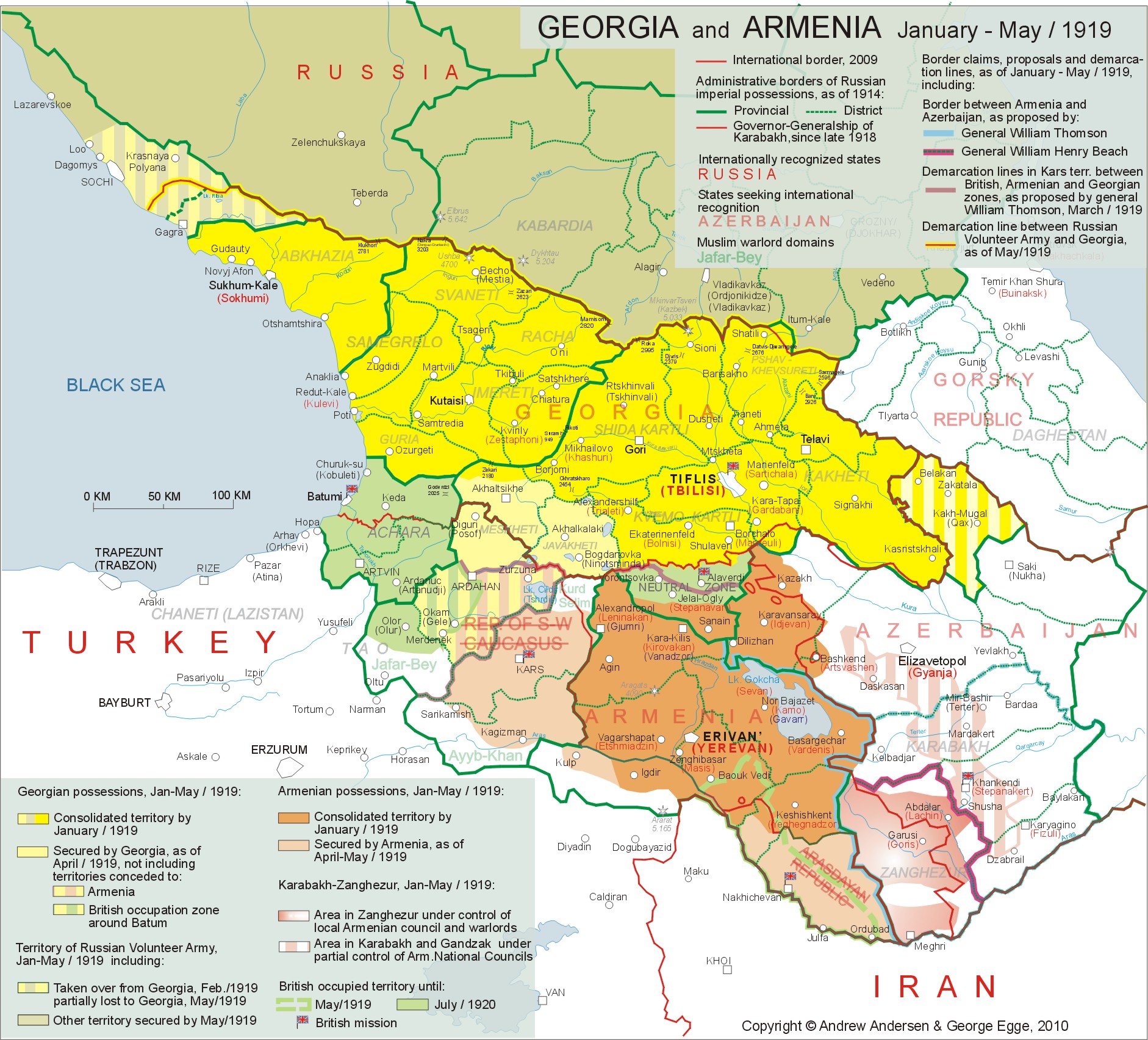
(see Maps 2 and 4). Armenia
versus Azerbaijan: The British Mediation Failure Mutual territorial claims of Armenia and
Azerbaijan led to the series of brutal wars accompanied by periodical
massacres of civilians in the disputed area that included Kazakh-Shamshadin,
Nakhichevan, Zanghezur and Karabakh. The first hostilities in the above and
other areas with mixed population occurred as early as the spring of 1918,
when the South Caucasus was invaded by the Ottoman armies to end in 1921
only.
The government of Armenia was not prepared
to drop their claims to Kazakh-Shamshadin, Zanghezur and Karabakh while
Azerbaijan was not accepting the idea of Armenian control over Surmala and Nakhichevan
- Ordubad. To make things worse, the masses of population of a number of
territories assigned to Armenia and Azerbaijan were not prepared to consider
themselves a part of the republics to which they were assigned by Thomson.
Thus the fragile peace with an unresolved territorial dispute at its
background could not last for too long, and the series of Azeri-Armenian wars
broke out both in the provinces of Erevan and Elizavetpol as early as at the
end of 1918. Contrary to Armenian aspirations and hopes
for special treatment following their uninterrupted loyalty to the Allies
throughout the whole of the Great War, the British Command in the South
Caucasus decided in the late fall of 1918, to leave the Karabakh-Zanghezur
area under the jurisdiction of oil-rich Azerbaijan at least until the moment
when the final delimitation agreement would be reached at the Paris peace
Conference[24]. That
led to a fragile diarchy in the Armenian-populated parts of Karabakh where
the Erevan-oriented People’s Government in Shusha that had been running the
area since July 1918, was forced to share its power with the British
appointee Dr. Khosrow Bek Sultanov who was given authority by Thomson to run
a considerable part (4 of 8 counties) of the province of Elisavetpol
including Mountaineous Karabakh and Zanghezur[25](see
Map.4). The following 8 months in Mountainous
Karabakh were marked with the total failure of cooperation between
consecutive Armenian Assemblies and Sultanov as well as with the non-stopping
ethnic conflicts that led to armed clashes between local Armenian
self-defense forces and the regular army of Azerbaijan that included some
3000 Turkish troops still stationed in the area[26]
and were assisted by armed militias recruited from Tatar and Kurd nomads of
western Karabakh. At the same period of time, almost the
whole county of Zanghezur was under stable control of Armenian military units
and formations of general Andranik who being formally disloyal to the
government in Erevan, felt quite free to act independently and crashed all
attempts of the regular armies of Turkey and Azerbaijan to put Zanghezur
under their control. Following the armistice of Mudros
and an appeal from the Armenian-controlled part of Karabakh, Andranik sent
his “Special Striking Division” out toward Shusha on November 29, 1918. After
three days of fierce fighting against Azeri-Kurd irregulars for a narrow
strip of land separating Armenian-controlled parts of Zanghezur and Karabakh
Andranik’s men had the way to the heartland of Karabakh unobstructed.
However, an urgent message from Major General Thomson received by Andranik on
December 03 contained an unequivocal order to move back to Zanghezur and to
refrain from taking any disputed territory by force until the decision of the
peace conference[27].
Andranik submitted and stepped down as a commander of the Armenian forces in Zanghezur
while Muslim militias wiped out all remaining Armenian settlements connecting
Karabakh with Zanghezur[28]. Despite repeatedly expressed aspirations of
the Karabakh Armenians for unification with Armenia, the government of the
First Republic in Erevan was reluctant to insist on immediate annexation of
Mountainous Karabakh rather leaning towards the creation of a buffer state in
the areas with mixed population east of Zanghezur[29].
Finally, on August 22, 1919, after long negotiations, an agreement was reached
in Shusha between the Seventh Assembly of Karabakh (Armenian-dominated) and
Sultanov in accordance with which Mountainous Karabakh (but not Zanghezur)
was to remain temporarily within Azerbaijan until the final resolution of the
conflict at the Paris Peace Conference[30].
In the county of Zanghezur that in
accordance with the initial plans of Thomson was to be included into the
special governorate of Karabakh run by Khosrow Bek Sultanov, the situation
was different. After disappointed with the British Major General Andranik
stepped down as a commander of all Armenian forces in Zanghezur on March 22,
1919[31],
local Armenian field commanders refused to submit to the British dictate.
After being pressed by British representatives they expressed their preparedness
to fight to the end against any power that would attempt to submit them to
Azerbaijan including Britain and France, Thomson agreed to exclude Zanghezur
from the list of ethnically diverse counties “temporarily” granted to
Azerbaijan. The government of Azerbaijani Republic was informed on that
concession on May 29, 1919[32].
By that time the Armenian militias of Zanghezur destroyed rebellious Muslim
communities in the central areas of the county and expelled them to the
periphery[33]. In addition to the five major historical
districts of Karabakh (Gyulistan, Khachen, Jraberd, Varanda and Dizak) there
is another area sometimes included into the disputed historical province.
That is the mountainous part of the Elizavetpol (Gyanja) county. The smaller
part of this area The smaller part of the described area south of the village
of Chaykend and north of Inja river (which also served as a border between
the counties of Elizavetpol and Javanshir) that embraced a group of ethnic
Armenian settlements forming a triangle with apexes in the villages of
Karachinar, Enghikend and Gyulistan, is the continuation of historical
Gyulistan whereas the remaining part of that mountainous territory
predominantly Armenian-inhabited until 1989, is referred to by various
historical geographers and politicians as Northern Karabakh, North-Western
Karabakh or Parisos. The Armenian communities of Parisos were not represented
at the Karabakh Assemblies (unlike those of Gyulistan). Instead they were
administered by the Armenian National
Council of Gandzak in Gyanja that in turn, demonstrated loyalty to Turkey
during Ottoman occupation and later – to Azerbaijan to the extent that two of
the Council members were selected to represent the area in the Azerbaijani
Parliament[34]. One should add to the above that there was
a considerable no-man’s land between Armenia and Azerbaijan in the upper flow
of the river Terter and around the mountains of Omar, Gyamysh, Jinaldagh,
Delidagh, Klyshdagh and Sarychly. It embraced south-western part of the county
of Gyanja, eastern part of Javanshir county and northernmost Zanghezur.
Having no infrastructure that mountainous area had almost no population
except a few nomadic tribes (predominantly Kurds relatively loyal to
Azerbaijan) that used to be present in the area in summer only and moved down
to the lower Karabakh in winter together with their livestock. During the
period between the fall of 1918 and the spring of 1920, the above-described
area was claimed by both Azerbaijan and Armenia but hardly any of the conflicting
parties could boast an effective control over it until the Soviet takeover in
May, 1920.
Map 4. Click on the map for better resolution
The delay proved crucial. By that moment
the pan-Turanist “Arasdayan Republic” was proclaimed in the disputed area[36]
and local anti-Armenian forces were armed and organized well enough to repel
or at least slow down possible Armenian expansion. The eruption of a new war
was this time prevented through Allied mediation and establishment of a
special British governorship on January 26, 1919[37].
The new British protectorate embraced most of the county of Nakhichevan
(excluding the mountainous area) all of Sharur and even some 30% of the
county of Erevan up till the river of Vedichay[38].
Although the area was excluded from the Armenian republic, the British
governorship put an end to the “Arasdayan Republic”[39]
leaving most of the real administrative power to Japhar-Kouli Khan of
Nakhichevan with the police functions performed by a small British
contingent. The spring of 1919 saw the reversal of
British sympathies for Muslim aspirations in the some areas of the South
Caucasus. The analysis of the reasons of such a reversal would go far beyond
the framework of this article. Here we can only mention that after a series
of talks performed by British emissaries in Tiflis, Erevan, Baku and Nakhichevan
the allied governorship was abolished and the British units stationed in the
area were to be replaced Armenian troops under General Dro (Drastamat
Kanayan). On May 16, 1919, the whole of Sharur, Nakhichevan and Goghtan were
put under formal Armenian control and By June 7 the last British units left
the disputed area. Thus by the beginning of the summer of
1919, the First Armenian Republic managed to put under her formal control
most o the territory that could be called “the former Russian Armenia” with
the exception of the Mountainous Karabakh (see Map 5). The temporary borders
of Armenia were reflected on the map prepared for presentation at the Peace
Conference in Paris by British Brigadier General William Henry Beach.
According to that map Armenia included most of the Kars territory as well as
all of the province of Erevan (including Sharur, Nakhichevan and Goghtan) and
the county of Zanghezur[40].
The map of Beach is a document of specially interest keeping in mind that
until April, 1919, its author (the head of the
British military intelligence in the Caucasus) was known as a
strong advocate of the inclusion of the counties of Zanghezur and Nakhichevan
into Azerbaijan[41]. Nevertheless, in the early summer of 1919
neither Armenian, nor Azerbaijani governments and elites believed that the
territorial dispute was over. The events that followed confirmed that the
status quo in the South Caucasus was quite fragile. Armenian
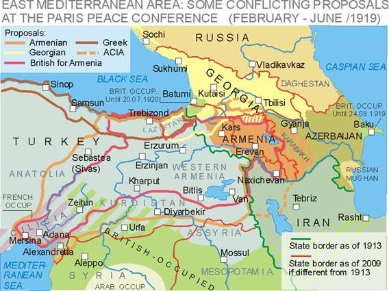
Question at the Paris Peace Conference: Territorial and Mandate Clauses During the spring and early summer of 1919
when the re-born Armenian state in the South Caucasus was trying to establish
firmly in the former Erevan province and Kars territory as well as in
Zanghezur and some other lands, the Armenian question was actively discussed
at the Paris Peace Conference. Despite Armenian aspirations the fate of
their country remained unclear and undecided[42].
The situation was further complicated by the fact that there were two
Armenian delegations sent to the conference: the National Delegation
representing the diasporas headed by Boghos Nubar Pasha and the Delegation of
the First Republic headed by Avetis Aharonian as well as by the absence of
consensus between the two delegations[43].
In addition to the above, the Armenians were excluded from the list of
national delegations at the Peace Conference because they did not represent
the people that “have not yet been received into the family of nations”[44] While at least in early February, 1919, the
delegation from Armenian Republic tried to be more pragmatic and restrict its
claims to the former Russian and partially, Turkish Armenia adding to it a
part of the vilayet of Trebizond in order to get access to the Black Sea, the
National Delegation voiced far more ambitious territorial claims aimed at the
creation of a vast Armenian state that would stretch itself from Black Sea to Mediterranean
coast and from the Caucasus to the Taurus and would include Cilicia where
local Armenian communities tried to build-up some self-government under the
protection of French civil administration and a small allied military
contingent[45].
According to Loris-Melikov, the delegation headed by Nubar was firm in its
claims partially due to the influence of Russian anticommunist diplomats
including Sazonov, who strongly believed in the soon fall of the Soviet
regime and re-unification of Armenia with Russia that would thus give Russia
an access to the Mediterranean ports of Adana, Mersina and Alexandretta[46]. Finally, the two delegations in Paris succeeded
in overcoming their differences and reach some modus vivendi and formed a united “Delegation of Integral
Armenia” that was prepared to present the Armenian case at the Peace
Conference[47].
According to the joint memorandum presented to the Conference by the
“Delegation of Integral Armenia” on February 12, 1919, the proposed Armenian state was
to include the following territories:
The Armenian proposal was identical to that
of the American Committee for the Independence of Armenia (ACIA) that was
lobbying Armenian interests in the US Congress and enjoyed support on behalf
of President Woodrow Wilson[49].
Figure 3.1 (does not include Iranian and
Azerbaijani proposals) At the very last moment the united Armenian
delegation agreed on the excluding an area around Maku in north-western
corner of Iranian Azerbaijan (historical Armenian province of Artaz) from the
above proposal in order to maintain good relations with the neutral Persia
(Iran)[50]. While recognizing both the substantive
input of Armenia in the Great War and the victims of the Armenian people,
most of the leaders of the Allied powers considered Armenian aspirations
rather excessive if not colossal[51].
They agreed that Turkey had to surrender all of her territorial claims to the
Caucasus but were not sure what part of Turkish Armenia could be awarded to
the Armenian Republic providing the absence of the Armenian population there
following the massacres of 1915 and 1918. The British delegation at the Peace
Conference recommended rounding off the prospective Armenian gains in the
seven vilayets while at the same time restricting the Caucasian possessions
of Armenia to the province of Erevan and most of the territory of Kars[52].
The French delegation was firm in claiming Cilicia and advocating its future
incorporation into Syria[53].
Finally, the Armenian aspirations in the vilayet of Trebizond (also known as
Paryadria or Lazistan) were in conflict with the doctrine of the government
of Greece (Megali idea) as well as
of various Pontic Greek organizations that considered restoration of a Pontic
Greek state with the centre in Trebizond as well as with the aspirations of
Georgia also claiming part of Turkish Black Sea coast and some land in the
basin of Chorokh[54].
Finally though, the Greek government of Eleutherios Venizelos revoked any
claims to Trebizond in favor of a prospective Armeno-Greek federation[55]
whereas Georgian claims were to some extent supported by Britain[56]. Despite there differences in the approach
to the Armenian question the leaders of the USA, Britain and France were
unanimous in their belief that the new Armenian state was incapable of fully
independent sovereign existence and thus needed to be placed under mandate of
one of the major victorious powers. Keeping in mind that both Britain and
France refused mandate for Armenia the only two remaining powers capable of
taking care of the vast prospective state were Italy and the USA. The
Armenian hopes definitely lay with the Americans and the US President Woodrow
Wilson who was one of the major advocates of Armenian aspirations. However,
President Wilson needed time to convince the US Congress that Armenian project
was worth the efforts and investments[57]. As a result of the above, the final
decisions regarding the peace treaty with Turkey and the future of Armenia
was deferred for at least two months by the decision of the Council of Four[58]
that was confirmed by a number of documents signed between May 13 and June
25, 1919[59]. That was a big diplomatic defeat of
Armenia. The country remained officially unrecognized, and after the end of
the first phase of the Peace Conference the Allied leaders were never again
to join together as a single body, and the golden opportunity to approach all
of them at the same time in order to resolve the Armenian question slipped
away in early summer of 1919[60]. |
|
|

![]()